
Research Directions
1. Tracking Earth's Rivers with Satellites
Rivers serve as a chief source of water to humans and freshwater ecosystems. They also organize landscapes, are integral to global biogeochemical cycles, and are responsible for some of the largest natural disasters in history. Despite their importance, observational assessments of river systems, based largely on river gauge data, are fragmented and often limited to country-level statistics, severely impeding our understanding of this important link in the water cycle. In contrast, satellite remote sensing data provide a globally consistent and spatially continuous tool for studying rivers.
We use satellite observations to quantify how the global river system is evolving in response to climate and land use change. We also quantify other important aspects of rivers including seasonal changes in inundation extent, floods and water quality, and predict how these properties are likely to change into the future.
Relevant Papers:

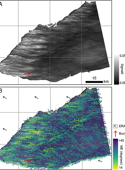
2. Novel Applications of the SWOT Satellite
The Surface Water and Ocean Topography (SWOT) satellite was designed for two primary applications: oceanography and inland hydrology. Primary mission requirements related to hydrology included measuring the discharge in rivers and storage change in lakes. However, SWOT's unique Ka-band radar enables a wide range of new applications in hydrology beyond its original mission objectives.
We analyze SWOT data to explore new applications of SWOT including measuring wind fields over lakes (based on water surface roughening), fluvial geomorphology, flow waves propagating down rivers, backwater profiles upstream of lakes, and lake seiche events.
Relevant Papers:
-
Stroud et al. (2025) SWOT Satellite: A New Tool for Fluvial Geomorphology. GSA Today
-
McQuillan et al. (2025) Estimating Wind Direction and Wind Speed Over Lakes With Surface Water Ocean Topography and Sentinel-1 Satellite Observations, Earth and Space Science
-
Thurman et al. (2025) SWOT captures hydrologic waves traveling down rivers. Geophysical Research Letters
3. Building Global Hydrography Datasets
Large-scale hydrologic models rely on accurate hydrography datasets to represent the movement and storage of surface water. The past decade has witnessed the development of several key global hydrography datasets that have transformed the understanding of surface water systems and how they are changing.
We build global geospatial databases that focus on Earth's inland waters including rivers, lakes, wetlands, hydrologically conditioned topography, and stream network topology.
Relevant Papers:
-
Allen et al. (2018) Global Estimates of River Flow Wave Travel Times and Implications for Low-Latency Satellite Data, Geophysical Research Letters.
-
Safat et al. (2013) Lake-TopoCat:a global lake drainage topology and catchment database. Earth System Science Data
4. Integrating Lakes and Rivers with the LakeFlow Algorithm
Although intrinsically related, river and lake systems are often studied separately using satellite remote sensing. The SWOT satellite provides surface water elevation and extent measurements of both river and lake systems at an unprecedented spatial resolution.
We use SWOT data and the LakeFlow algorithm to link lake and river hydrologic processes over large scales. LakeFlow estimates the inflows and outflows of lakes using a mass balance approach. LakeFlow can be used to improve representation of water flux and storage within river networks and is incorporated into the SWOT mission's official river discharge product framework.
Relevant Papers:

5. Satellite Mission Design for Monitoring Inland Water Quality
Space-based earth observation is undergoing a revolution driven by low-cost launch options and commercial, off-the-shelf small satellite technology, and improvements in data transmission and storage options.
In anticipation of developments over the next decade, we are formulating innovative and iterative mission designs focused on observing the quality of Earth's rivers, lakes, and coastal zones. Given that these water features often necessitate data with both high spectral and high spatial resolution, our research emphasizes unconventional observation strategies like reactive planning and slewing, agile sensor webs, and SmallSats constellations.
Relevant Papers:
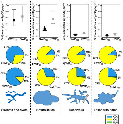
6. Greenhouse Gas Emissions from Inland Waters
Rivers and lakes emit significant amounts of greenhouse gases to the atmosphere and are integral to greenhouse budget evaluations. A key parameter used to estimate water-atmosphere greenhouse gas flux is the surface area of Earth’s rivers and lakes because a larger surface area represents a larger medium for gas exchange.
Our research offers the best estimates of the surface areas of rivers, lakes, reservoirs, ponds, and wetlands for use in global greenhouse gas budgets. We also develop new approaches for estimating global inland surface water areas by applying geomorphic scaling rules to satellite-based observations.
Relevant Papers:
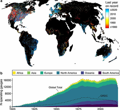
7. Supplementing Global River Gauge Records from Space
River gauges are widely considered to be the “gold standard” source discharge data that is used for river science and water resource management. Yet gauge data are inaccessible in many parts of the world often due to restrictions on sharing data by national gauge agencies (Nature Sustain. 2023). While many of these agencies prohibit sharing of gauge data, they do not prohibit accessing gauge data on their websites. The Global Rivers Group developed the first software package to download river discharge records of thousands of gauge stations worldwide (RivRetrieve Package). This software automates the access, downloading, and processing of river discharge and stage data, opening up important and up-to-date observations of a key link in the Earth’s water cycle.
Relevant Papers:
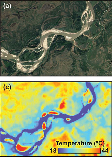
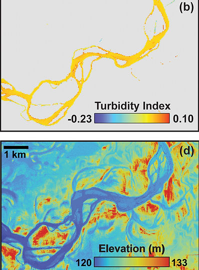
8. Measuring Global River Temperatures
The temperatures of Earth’s rivers are predicted to be rising due to changes in land use and climate. These predictions are largely based on in-situ temperature measurements combined with process-based models. However, over large areas, in-situ temperature measurements are sparsely distributed leading to high uncertainty. On the other hand, satellite thermal remote sensing enables spatially-distributed measurements of river temperatures worldwide. Yet there has been no effort to measure river water temperature at the global scale using remote sensing data, likely because until recently, such an endeavor would have been infeasible.
We measure river warming over large scales using thermal remote sensing data and then using these temperature measurements to identify sources of thermal pollution and predict future river warming trends.
Relevant Papers:
-
Ellis et al. (2026) Satellite observations reveal widespread alteration of river thermal regimes by U.S. dams. Science Advances.
_edited.jpg)
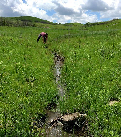
9. Headwater Stream Hydromorphology
Headwater streams comprise an estimated 89% of the global fluvial network length and are the source of water, sediment, nutrients, and organic matter for downstream systems. They exhibit highly variable physical, chemical, and biotic attributes; as a result, they contribute to significant biodiversity within watersheds. They are also more hydraulically coupled to hillslope and groundwater processes compared to larger streams and thus are hotspots for biogeochemical activity. The morphology and abundance of streams control the rates of hydraulic and biogeochemical exchange between streams, groundwater, and the atmosphere.
We integrate field methods, drones, and satellite data to quantify emergent behavior of headwater stream hydromorphology and understand how these important constituents of the landscape are changing.
Relevant Papers:
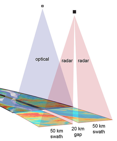
10. Multi-Sensor Data Fusion in Hydrology
The field of hydrology stands benefit from novel fusion of many existing observational and model datasets. Disparate observations can often be combined to measure complementary components of the same system. Many low-resolution orbiting sensors provide frequent measurements of Earth's surface but at low resolution, while others measure at high spatial resolution but do not have a fast repeat orbit. Aerial techniques can be very high resolution, but are temporally sporadic with limited coverage. In situ measurements produce continuous, high-quality observations but are limited in spatial coverage.
We apply geospatial analysis and remote sensing science to assess the potential synergism between multiple sensors, and utilize these relationships to provide a more accurate, and often a more holistic understanding of Earth's water resources.
Relevant Papers:
_edited.jpg)
We welcome collaborations with researchers, students, government agencies, and industry partners interested in advancing the science and monitoring of inland waters